Event JSON
{
"id": "c0c89354b80067a0a197f7261a1d9a8812409d6365a510c63ca66ad868b43e3c",
"pubkey": "214a8fe93817d9553711f97ea469730bfe38bc458fb2f18edd899b85141f1ae3",
"created_at": 1733192357,
"kind": 1,
"tags": [
[
"t",
"OpenStreetMap"
],
[
"t",
"eugeneoregon"
],
[
"imeta",
"url https://cdn.masto.host/enosmtown/media_attachments/files/113/586/471/833/515/489/original/4868c8c4ec374be3.png",
"m image/png",
"dim 517x184",
"blurhash USPZ$8t7RjIU4pR%t7t7xut7oft7~Wj[RjRj"
],
[
"imeta",
"url https://cdn.masto.host/enosmtown/media_attachments/files/113/586/486/231/193/308/original/7c5590c7d62d16d3.png",
"m image/png",
"dim 975x1015",
"blurhash UAPGZ:?ELK%~||+}KwcFK}t8xHs;yXNZH=ae"
],
[
"proxy",
"https://en.osm.town/users/watmildon/statuses/113586494317975485",
"activitypub"
]
],
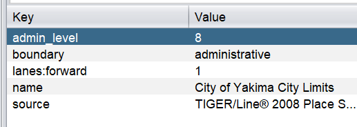
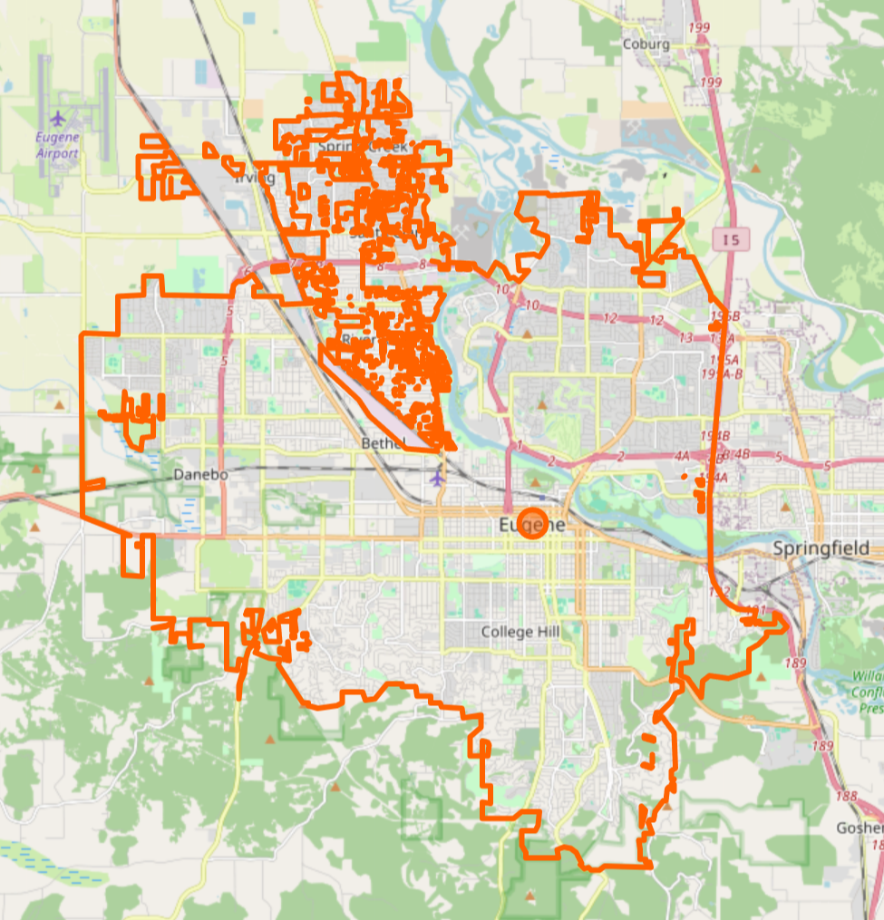
"content": "Because I am very easily trickable, I have been spending a lot of time cleaning up boundaries and boundary tagging in the US.\n\nYou always find silly things like the tagging on this piece of the Yakima city boundary... oooorrr whatever the heck is going on with the Eugene OR boundary. [1]\n\n[1] https://www.openstreetmap.org/relation/186706 \n\n#OpenStreetMap #EugeneOregon\n\nhttps://cdn.masto.host/enosmtown/media_attachments/files/113/586/471/833/515/489/original/4868c8c4ec374be3.png\nhttps://cdn.masto.host/enosmtown/media_attachments/files/113/586/486/231/193/308/original/7c5590c7d62d16d3.png",
"sig": "34ee4bf4d3cc9dbe1eef7d22c92497d9c93485779f0a2b6fdd7a890be3a0daa0d368ae1b216839398ad098fa3cbbedfe928cab4e55cdd2d34b17f99931da8174"
}